

National Imperative and Challenge
Spatial targeting, prioritisation and alignment are seen as key to national imperatives of addressing poverty and inequality (NDP, 2011), to improve quality of life and access to services as set out by international and national targets (SDGs), as well as to achieve the principles calling for spatial transformation, sustainability, efficiency and social justice (SPLUMA, 2013). Within this context, the call for social justice with respect to constitutionally provided human rights provides a clear basis to ensure that people are not denied access to essential services because of where they live. A decade of research on social facility provision standards undertaken in conjunction with spatial analysis to inform location planning clearly demonstrates the operational challenges to provide a full range of social facility types in all parts of the country with the same intensity or service levels in a sustainable, economically viable and efficient manner. The spatial analysis was undertaken based on these standards with the aim of not only informing location planning but to test, verify and adapt the standards to local conditions and to, within reason, modify the standards to be practical, affordable and implementable while taking due cognisance of meeting goals of spatial equity and justice with respect to social service provision.
To meet the needs of citizens for social service access in a way that considers and balances this against the operational needs of service providers requires that a systematic approach is followed for the provision and location of these services. The approach must take into consideration the evidence with respect to likely frequency of use, type of service provided, population need and density, distances people must travel to access services or are prepared to travel for services as well as access to qualified staff, logistics of supply delivery and the service reach of different levels of service.
Spatial Logic and Service Hierachies
The spatial logic of linking different population thresholds to different types and sizes of services is well recognised and established internationally. This logic has been used for linking certain levels of facilities to an order of space or place. This is illustrated in the relationship between levels of settlement/living environment, distance threshold and facilities types as seen in Shaping Neighbourhoods: for local health and global sustainability, by Hugh Barton, Marcus Grant and Richard Guise-2nd ed. (2003, 2010) as well as the relationship between service function, facility provision and levels of settlement type highlighted in the Irish Development Plan (Strategic Investment Board Limited, 2008).Within the South African context, this spatial logic has been tested and customised while executing a range of implementation projects over more than 15 years and these are outlined in The CSIR Guidelines for the Provision of Social Facilities in South African Settlements.
This guideline provided a similar framework that follows the spatial logic where different sizes of towns are shown to be able to support a different range of facility types with increasing number, level of specialisation and size of facilities linked to increasing population size and settlement hierarchy. This enabled planners to then apply specific types of facilities and provision ratios for different population sizes. The guideline standards presented for the social facilities types and standards have as far as possible been adapted for South African application and government social facility offerings. In 2016, a further differentiation and detailed refinement of the provision standards was undertaken to specifically accommodate their application in more rural areas of South Africa. The purpose was to provide a finer differentiation of facility types at the lower end of the facility scale to define viable service options for more sparsely developed and remote areas outside of towns.
This differentiated standards defined outlined the risks of undue proliferation of too many small facilities that could hamper the potential of developing larger shared facilities of higher level in some areas. The larger facilities are in general operationally more efficient and they can provide access to a wider and higher range of services offerings. To facilitate the planning of larger shared facilities, service catchments were defined for the whole country based on principles of central place theory and road accessibility. Each of the service catchment areas that were defined have been profiled with respect to a range of demographic and settlement factors. These profiles can be accessed through the Social Facility Provision Toolkit. (See list of resources below). The evidence generated through this profiling is specifically relevant to enable the systematic detail level application of facility provision standards.
Linking Services and Town Hierachies
However, a key gap remained with respect to the effective and sustainable application of social facility standards within the country when applying the spatial logic of settlement hierarchy. The key concern related to the uneven distribution of towns of different sizes and types across the South African landscape. Settlements are not uniformly distributed as theorised in Christaller’s central place concept. Thus if facilities were allocated with standards based on settlement hierarchy or catchment population alone, provision would not result in spatial equity and social justice principles as required in terms of SPLUMA principles of equity and spatial justice. The reason being that it is likely that in some areas where no large towns are found, certain higher order facilities many not be planned and that in other areas where several medium to large towns are located close together, some services may have overlapping service catchments and facilities would compete for the same demand leading to lower operational efficiencies. In some cases it was possible to heuristically identify a suitable ‘potential higher order service point’ with ease (i.e. in the north-western Cape it was simple to identify Springbok as the highest order place); however, this was not as easy in other regions. More specific criteria were needed to make an informed and rational choice between two or more competing places.
Thus, using the SACN/CSIR 2010 settlement typology as a starting point, a first round selection process was undertaken to identify all higher order full range service points. This process identified all major cities and regional service centres after which a heuristic evaluation of Service Towns and Niche Towns was undertaken to ensure an adequate spread of key ‘middle’ order service locations across the country. To enable robust, empirical spatial targeting of all remaining places (including Service Towns not selected as part of the first round), a spatial optimisation analysis was undertaken to iteratively identify the most optimal towns and villages that could be used to provide middle order services and which did not already fall within 30km of an already selected service point. The selection criteria were based on population density and concentration within 30km from identified towns and villages provided at least 5000 people lived within reach. The analysis tested the potential to spatially target social investment of middle order facilities which have a 30km service reach (50km in the sparser western areas) and to still maintain a high service coverage percentage of the population. The results showed that the identification of 369 Priority service points with a range of population sizes can be used to rationalise and spatially target social facility investment. The key finding was that using this approach, it was possible to reach over 90% of the country’s population from only 378 service points and almost less than 50% if all catchments were to be provided with such services. For more details on this process please see the technical report available here
A short note on the results, process and relevance of the prioritisation is also provided on the stepSA site (spatial targeting). This process of spatial targeting and rationalisation provided a key input to the most recent updated and refined typology of South African Town Typology. Early in 2018, the South African Town Typology was updated to provide a place specific typology of functionally linked South African cities, towns and villages that is more finely differentiated with regard to smaller settlements than any previous national scale typology and incorporated the results of the spatial targeting process. Thus the classification takes into consideration the specific spatial location and role of the town within the surrounding hinterland in conjunction with the population size and the level of economic activity in its classification. In this way, the South African Town Typology and the use of the word ‘Service’ in its nomenclature, takes into consideration and gives support to regionalised social services provision. In using the spatial prioritisation of places, the typology could specifically account for the role of each town within its surrounding hinterland and its potential service role to smaller surrounding places. In this way, it identifies where it is best to locate services to redress service delivery that resulted from poor historical development, political factors or underlying resource/geo-physical conditions. The SA Functional Town Typology introduces a typology of seven types namely: (1) City Regions; (2) Cities and Large Regional Centres; (3) Regional Service Centres; (4) Service Towns; (5) Small Service Towns; (6) Rural Service Centres; and the combination of (7) Small Towns as well as Rural Settlement Areas and other Sparsely Populated Areas. (See Martiz et al stepSA 2018).
The Service Wheel
The conceptual relationship between the South Africa Town Typology and the social facility standards is illustrated in the form of a service wheel. The ‘Service Wheel’ provides an illustration of the ‘ideal’ relationship between the size and role that different types of places can or should play with respect to the strategic location of different categories of social services that would typically be associated with (and expected to be delivered by) such level of place, and serve both for its residents and those living within its service region. To better inform the specific allocation, provision and distribution of services to any town and surrounding catchment area, will require a location specific analyses and application of relevant standards as outlined in the application guides provided as part of the Toolkit.
Service Wheel
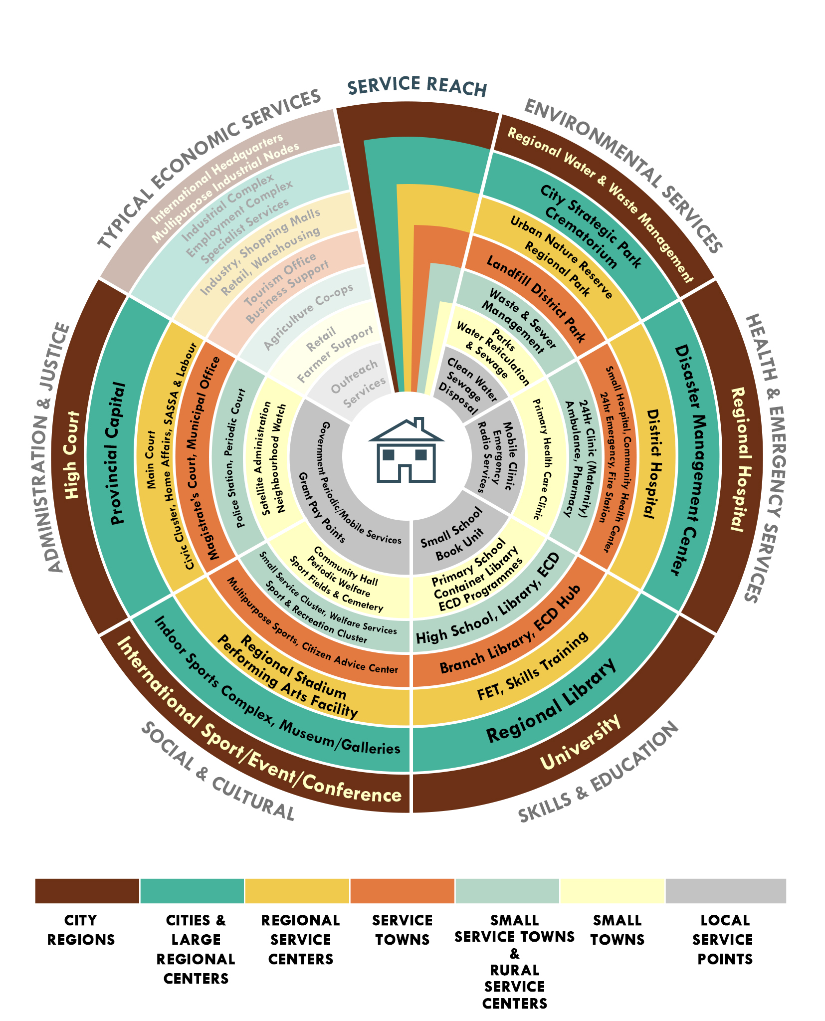
The wheel illustrates in different colours (see legend) from the outside to inward, a declining hierarchy of settlements and for each settlement level, examples of appropriate service types are indicated. The wheel is broken into seven segments. The segment labelled “Service Reach” indicates the typical reach of service; from the level at which it is provided to the furthest point it is likely to serve. The service types are broadly grouped into functional grouping in the other segments. It also shows (greyed out) the typical economic services likely to occur in a settlement of a specific level. With respect to lower order basic services, all places should be provided with a proportional share of basic services (water, sanitation, education and basic health care) as close to home represented in the centre of the wheel. The lowest order of places shown on the ‘Service Wheel’ is the Local Service Points. The latter have not yet been separately defined within the SA Typology of places but will be provided as part of the next update.
In the interim the smallest category of Priority places can be identified using the Social Facility Provision Toolkit and its lists of towns, catchments and identified list of prioritised places in the Social Facility Provision Toolkit. In addition to basic services, specific middle to higher order services such as 24hr health facilities and citizen registration should be provided at Local Service Points on regular but less permanent basis as these places play a lower order but significant service role in their hinterlands. Such service wheels serve only to illustrate the conceptual link between settlement levels and or distance threshold for a facility type. The use of the wheel or any checklist of facilities cannot be used as a substitute for the dedicated application of the appropriate Social Facility Provision Standards and Guidelines in the context of a detailed analysis of current supply and demand of facilities. For more resources please consult the list of resources at the end of this article.
Toolkits
Two free Toolkits for calculating facility demand are available on the Internet to assist in the demand estimation of facilities. These are the Social Facility Provision Toolkit and the CSIR Space Planner. The difference between the two tools is explained in the text box alongside. These tools should be used in conjunction with the relevant guideline documents and application guides.
For more information or enquires please contact:
Johan Maritz
jmaritz@csir.co.za or
Elsona van Huyssteen
evhuyssteen@csir.co.za
Core Team:
Chéri Green, Elsona van Huyssteen, Gerbrand Mans, Johan Maritz, Dave McKelly, Zukisa Sogoni, Mawande Ngidi
Key Resources:
- CSIR Space Planner
- CSIR Guidelines for the Provision of Social Facilities for South African Settlements
- Social Facility Provision Toolkit
- Guidelines for the Differentiated Provision of Social Services in Rural Areas
- Application Guide for Social Facility Provision Toolkit
Acknowledgements:
- Council for Scientific and Industrial Research
- Department of Rural Development and Land Reform
To be referenced as:
- Chéri Green, Zukisa Sogoni, Valentine Ragoasha. 2018. Socially Just and Rational Social Services Provision for South African Settlements. CSIR document. Available on stepsa.org